Maps are graphics that show any aspect of the Earth reduced using a series of conventional signs that store a large amount of data. They are an important source of information and essential for a lot of subjects. Geological maps are representations on a topographic base of different types of rocks located on the surface that outcrop in some region and of their space disposition and relationships between them (contact types) as well. This is the way geologists have to keep in order their field observations. It is a useful tool for transferring knowledge.
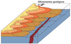
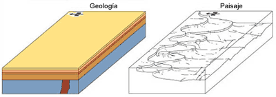
Geological maps are the result of geological structures intersection with topography. Geological cartography problems cannot be tackled without having a minimum knowledge of geology.
To be understandable all maps must have a key (legend) explaining the graphical meaning of all the elements of the cartographic representation (colours, symbols, patterns, etc.) Because of that, reading a map should be as easy as reading a novel.
The first thing to interpret are colours (very often replaced by patterns.) Each colour represents a group of rocks of a particular age and lithology. The meaning of each colour can be found in the legend of the map in order (depending on their age, from the oldest –on the bottom- to the newest –on the top-.) To avoid interpretation problems and confusion between colours of similar tones, we usually give a code (letters and numbers) to each colour. In the legend there is also a description of rocks that compose each lithological unit.
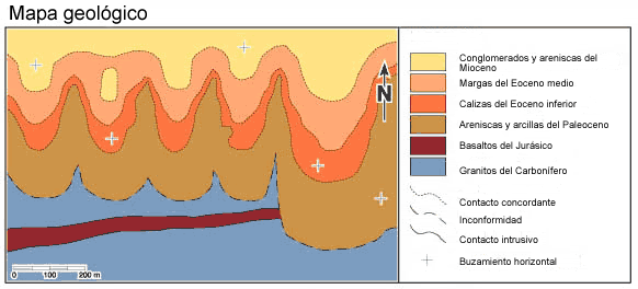
There is some criterion, not respected in all maps, to assign a colour (with different tonalities) to each geologic time unit. Thus, pale grey colours represent the Quaternary; yellow, the Upper Tertiary; orange, the Lower Tertiary; green, the Cretaceous; blue, the Jurassic, etc. This makes easier to get a first idea of distribution and extent of each time unit. Even so, it is indispensable to check the meaning of each colour.
Making and analysing geological sections is very helpful for understanding maps and to place planes and geologic structures properly in space. Geologic sections show the material structural disposition and make easier interpreting the events that have occurred in the mapped area.